|
|
| Back to Home page |
|
Thriplow is situated on
chalk downlands with the church at the highest point.
The geology has created favourable conditions for people to settle: in particular there are springs in the centre of the village and soils, overlying chalk, which are fertile, well drained and suitable for agriculture. Once cleared of woodland the downlands became an ancient routeway across the country. There are useful resources within the parish: flints for tool making and building, a band of hard chalk called clunch also for building, and areas of woodland and gravel.
|
||
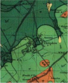
| Most noticable in this map is the line of sites along the chalk downland where springs erupt at Fowlmere, Thriplow, Chronicle Hills and beyond. These springs arise because of the impermeability of the chalk marl in the Lower Chalk layer. The springs in Thriplow arise near the centre of the village and are the sources of the stream which flows North towards Newton and then into the Rhee. |
|
KEY to map colours.
There are two main layers of chalk: Around the edges of the parish are
areas of Harder bands of rock lie within the main layers. The Melbourn Rock is shown as a dark green line between the two chalk layers. |
| The Melbourn Rock is known locally as clunch and has been used successfully in the village as a building material, provided that it is protected from the rain by plaster. An open clunch pit remains in the south of Middle Street. | ||
| Although all the Upper Chalk layer in the parish has been eroded away the hard flints found in this layer, being more resistant, have remained and provided a useful resource for earlier inhabitants of Thriplow. Evidence exists of their use in tools and wall building. | ||
| Sources of gravel were also valuable, especially in a time when lanes could quickly turn into muddy tracks. | ||
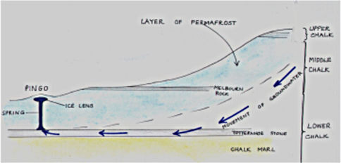
| In the last two million years there have been many cycles of spreading and retreating of ice sheets over Britain. During the intense cold but non glaciated times permafrost in Thriplow penetrated 6-16 metres. Periglacial effects have had a large impact on the surface geology of Thriplow. | ||
|
|
There is a picture of one of these effects on the Pond Dipping page. Pingos, (pingo is an Inuit word meaning "conical hill"), were formed during the Ice Age. |
|
| The diagram above shows how the movement of groundwater was inhibited by the impervious layer below and by the frozen layer above. It is under pressure and where a weak point in the chalk occurs, the water which is slightly acidic, gradually melts up through the permafrost, dissolving some of the chalk at the same time. The water in this rising stream is super cooled and so as it nears the surface it freezes into a frozen pond or a lens of ice. This ice pushes up a mound of soil above it. | ||
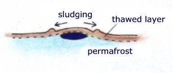 |
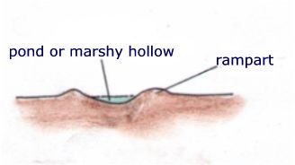
Gradually the material above the ice lens will slip downwards, aided by daily and yearly warm cycles, forming a ring of debris around the pingo. | |
  |
||